Archive Record
Images
Metadata
Title |
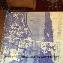
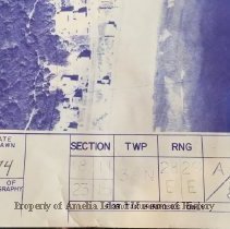
Aerial Photo of SR200/ AIA and Egan's Creek |
Object Name |
Photograph |
Scope & Content |
This aerial photo centers on SR200/A1A running west to east across Amelia Island and Egan's Creek running north to south. The eastern border is the Atlantic Ocean. Fletcher Road is labeled SR105 A1A. The route of A1A has been changed since the photo was taken and labeled. Sec 18/ 11 23/15 Twp 3N RNG 28/29 E/E A/8 |
Object ID |
2010.011.001 |
Collection |
AIMH |
Caption |
SR200/A1A |
Number of images |
2 |
Search Terms |
Egan's Creek Fletcher Avenue Florida State Road 200 Florida State Road A1A Sadler Road |
Date |
1974 |