Archive Record
Images
Metadata
Title |
Navigational information of Amelia Island in 1779 |
Object Name |
Map |
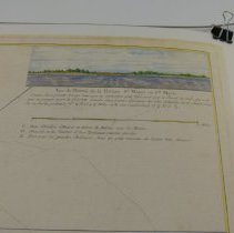
Scope & Content |
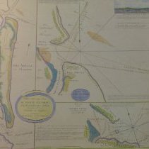
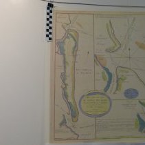
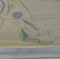
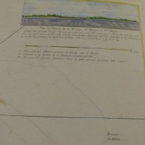
An artist rendering of a 1779 map made in France. This contains the work of Captain William Fuller, Jacob Blamey, Antione de Sartine, William Gerard De Brahm and Thomas Jefferys. The original is housed at the University of Florida, Gainesville,FL, George A Smathers Library. A chart containing the soundings and navigational information surrounding Amelia Island and the mouths of the Nassau and St. Mary's rivers in Florida. The two charts on the right were made from surveys by Captain William Fuller. The plan of Amelia Island is noted as being taken from William De Brahm's monumental large map format of South Carolina and Georgia, published in 1757. The map was made by Thomas Jefferys. A prospective view of the entrance to the St. Mary's River is inset at upper right. The map is dedicated to the Right Honorable John Earl of Egmont. The largest map, A Chart of the Entrance into St. Mary's River, features the northern end of the island and the waterway that runs between it and Cumberland Island, Georgia. The plan notes the depth soundings and locations of the shifting shoals that posed a great threat to mariners. The map also illustrates the "New Settlement, with its ordered grid of streets planned by the British, shown near the northern tip of Amelia Island. Across the river on Cumberland Island, the outlines of the abandoned Fort William are depicted. Founded in the 1740's by Georgia governor James Oglethorpe, the Fort was built to guard the southern approaches of the colony from the Spaniards, who were based in nearby St. Augustine. The map also features a fine navigator's view of the entrance of the river, in the upper right corner |
Object ID |
2009.008.001 |
Collection |
AIMH |
Caption |
Artist rendering Plan of Amelia Island 1770 |
Number of images |
5 |
People |
Fuller, William de Brahm, John William Gerard de Sartine, Antione Blamey, Jacob Jefferys, Thomas Perceval, John (Earl of Egmont) Oglethorpe, James Edward |
Search Terms |
Fort William |
Subjects |
Maps |
Date |
Unknown |
Year Range from |
1770 |
Year Range to |
1779 |