Archive Record
Images
Metadata
Title |
Florida First National Bank Road Map |
Object Name |
Map, Road |
Scope & Content |
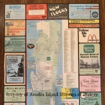
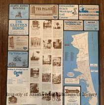
This map was produced by the Florida First national Bank in 1977 to advertise the island and island businesses. Copyright Bowden Publications. Drafted by Janet E. H. Deane. Graphics by Phillip Andrews. This map shows the north end of Amelia Island beginning at Fort Clinch State Park and continuing southward showing the City Limit to just south of the airport. The reverse shows a Walking or Driving Tour of Centre Street with descriptions of historic homes and buildings and the southern end of the island including Amelia Island Plantation. |
Object ID |
2005.063.001 |
Collection |
AIMH Maps |
Caption |
Florida First National Bank Map |
Number of images |
2 |
Search Terms |
1878 Steak House Amelia Insurance Agency Amelia Realty, Inc Amelia Rental and Management Art's True Value Hardware Atlantic Seafood Attic Store Barnett Bank Beachside Motel Carswell Insurance Company Clothes Horse Curtiss H. Lasserre Realty Fernandina Beach Municipal Golf Course Fernandina Beach Realty, ERA Florida First National Bank Lasserre Motor Company Manna Nutrition Center Mary K's Department Store McDonalds Palace Saloon Partin's Partin's Paul C. Burns Real Estate Ship's Lantern Surf Seafood Restaurant Vera Boner and Associates Real Estate Village Store and Bike Rental Walking Tour |
Date |
1977 |