Archive Record
Images
Metadata
Title |
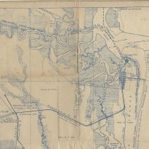
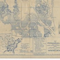
Map of Fernandina, Fla. and vicinity showing industrial & tourist potentialities |
Object Name |
Map |
Scope & Content |
Map of Fernandina, Fla. and vicinity showing industrial & tourist potentialities. Some Fernandina industries and their annual production: 1. 13 fish & shrimp packers (130,000 cases canned shrimp, 25,000 bbls. raw shirmp, 4000 bbls. fish) 2. 3 fertilizer and fish oil factories (300,000 gals. fish oil, 7000 tons stockfood, 4000 tons fertilizer) 3. 1 phosphate elevator (65,000 tons) 4. 2 boat builders (60 to 70 boats, average value $5000) 5. 1 saw/planing mill (5,000,000 f.b.m.) U. S. Coast Guard, Section Base 20 Keystone Hotel (32 rooms) Southern States Power Co. Fernandina Glider Club Map was compiled by R. A. Smith, B.C.E., City Manager Inset shows inland waterways of the United States with comment: "Draw a line from St. Marks to Fernandina and behold the missing link." |
Object ID |
1991.046.101 |
Collection |
AIMH Maps |
Caption |
Map of Fernandina , Fla. and vicinity |
Number of images |
2 |
People |
Pelote, J. Saures, Thom Vaughn, J. I. Harrison, S. Lamb, Thos. Harrison, Samuel Teran, Francis |
Search Terms |
Amelia Island Talbot Island Nassau Sound Atlantic Ocean Crany Island Kingsley Cut Harrison Creek Sawbit Creek Nassau River Amelia River S.A.L. Railway |
Subjects |
Maps Islands |
Date |
Jan. 1930 |