Archive Record
Images

Metadata
Title |
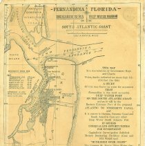
Map of Cumberland Sound area |
Object Name |
Map |
Scope & Content |
A map of the Cumberland Sound, the northern half of Amelia Island, Tiger Island, the southern tip of Cumberland Island, and the mouth of the St. Mary's River. The map was produced by the Fernandina Chamber of Commerce as a means of promoting Fernandina as a port, an investment opportunity, and a healthy city. |
Object ID |
2012.052.146 |
Collection |
AIMH |
Caption |
Map (front) |
Number of images |
2 |
People |
Lohman, Harry D. |
Search Terms |
Amelia Island Lighthouse Amelia River Camden County Carnegie Estate Cumberland Island, GA Dungeness Fernandina Chamber of Commerce Florida Terminal Co. Fort Clinch H. D. Lohman, Plumbing, Tinning, and Electrical Work Keystone hotel Kingsley Creek Nassau County Old Fernandina Seaboard Air Line Railroad St. Marys River Tiger Island U. S. Quarantine Station |
Subjects |
Chambers of commerce Maps Business enterprises Shipping Harbors Coal Advertising Plumbers Electrical apparatus Railroad companies |
Date |
1927 |