Archive Record
Images
Metadata
Title |
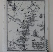
The Spanish Missions of GA & FL 1500 to 1763 |
Object Name |
Map |
Scope & Content |
The Spanish missions along the coast of Georgia and northeast Florida established 1500 - 1763. The map shows the position of Mission Santa Maria on Amelia Island. The map was drawn by John Tate Lanning in 1935. The map is not accurate and is not drawn to scale. 3 copies 1 plastic, 2 paper. The original map is held by the Georgia Historical Society. |
Object ID |
2009.006.001 |
Collection |
AIMH |
Caption |
Spanish Missions of GA & FL |
Number of images |
1 |
People |
Lanning, John Tate |
Search Terms |
Mission Santa Maria |
Subjects |
Missions |
Date |
1935 |
Year Range from |
1500 |
Year Range to |
1763 |